DJI Terra – What’s New
DJI Terra continues to lead the drone mapping industry as a comprehensive software solution designed for professional surveying, mapping, and 3D reconstruction. This powerful platform enables industry professionals to seamlessly transform real-world environments into precise digital assets using DJI Enterprise drones. The latest version 5.0.0. now support photorealistic Gaussian Splatting for visible reconstruction projects, providing both 2D and 3D outputs. These updates deliver unprecedented speed, accuracy, and visual quality that meet the demanding requirements of modern mapping professionals.
Photorealistic Gaussian Splatting
Introduction of the photorealistic 3D Gaussian Splatting technology, marking a revolutionary advancement in drone-based 3D reconstruction. This new technique generates incredibly detailed and realistic 3D models directly from standard drone photography, delivering results that surpass traditional photogrammetry methods.
Gaussian Splatting excels at capturing complex environmental elements that have historically challenged conventional reconstruction techniques. Fine architectural details, transparent surfaces and reflective materials are now rendered with exceptional accuracy and visual fidelity. The technology produces distortion-free orthomosaics while maintaining natural rendering effects that closely mirror real-world appearance.
Performance improvements are equally impressive, with DJI Terra processing approximately 500 photos per hour and completing single-block modelling tasks in just 30-40 minutes. For large-scale projects involving over 10,000 images, reconstruction speed doubles compared to traditional Terra Mesh processing, establishing new industry benchmarks for efficiency.
The software resource optimisation enables city-scale reconstruction projects, processing 300-400 photos per 1GB of available RAM while handling up to 30,000 images in a single task. This capability makes Terra 5.0 ideal for comprehensive urban digitalisation, smart city initiatives, and large-scale infrastructure projects.
Export flexibility ensures seamless integration with existing workflows through support for mainstream formats including PLY and B3DM (3D Tiles). This standardisation facilitates cross-platform compatibility and enables efficient data sharing across surveying, gaming, and film production industries.
Another changes:
Redesigned Interface – Version 5.0 features a completely redesigned user interface with reconstruction parameter templates for a smoother, more user-friendly experience
Enhanced License Options – Standard and Flagship versions are now available, with the Flagship version including support for visible light Gaussian Splatting reconstruction
Latest Hardware Support – Native support for NVIDIA’s latest RTX 50 series (Blackwell architecture) graphics cards ensures optimal processing performance
Expanded Drone Compatibility – Comprehensive support for detailed inspection projects using DJI Matrice 4T, 4D, 4TD, and 4E drones
Advanced Export Formats – Export 3D mesh models in FBX format for seamless integration with engineering, film, and gaming applications
Optimised Point Cloud Storage – Support for exporting 3D point clouds in LAZ format, which uses significantly less storage space than traditional LAS format
Enhanced Mapping Capabilities – Support for 2D map reconstruction using orthophoto data from the DJI Matrice 4T
Global Compatibility – Adds support for Japan’s JPGEO2024 elevation coordinate system, expanding international usability
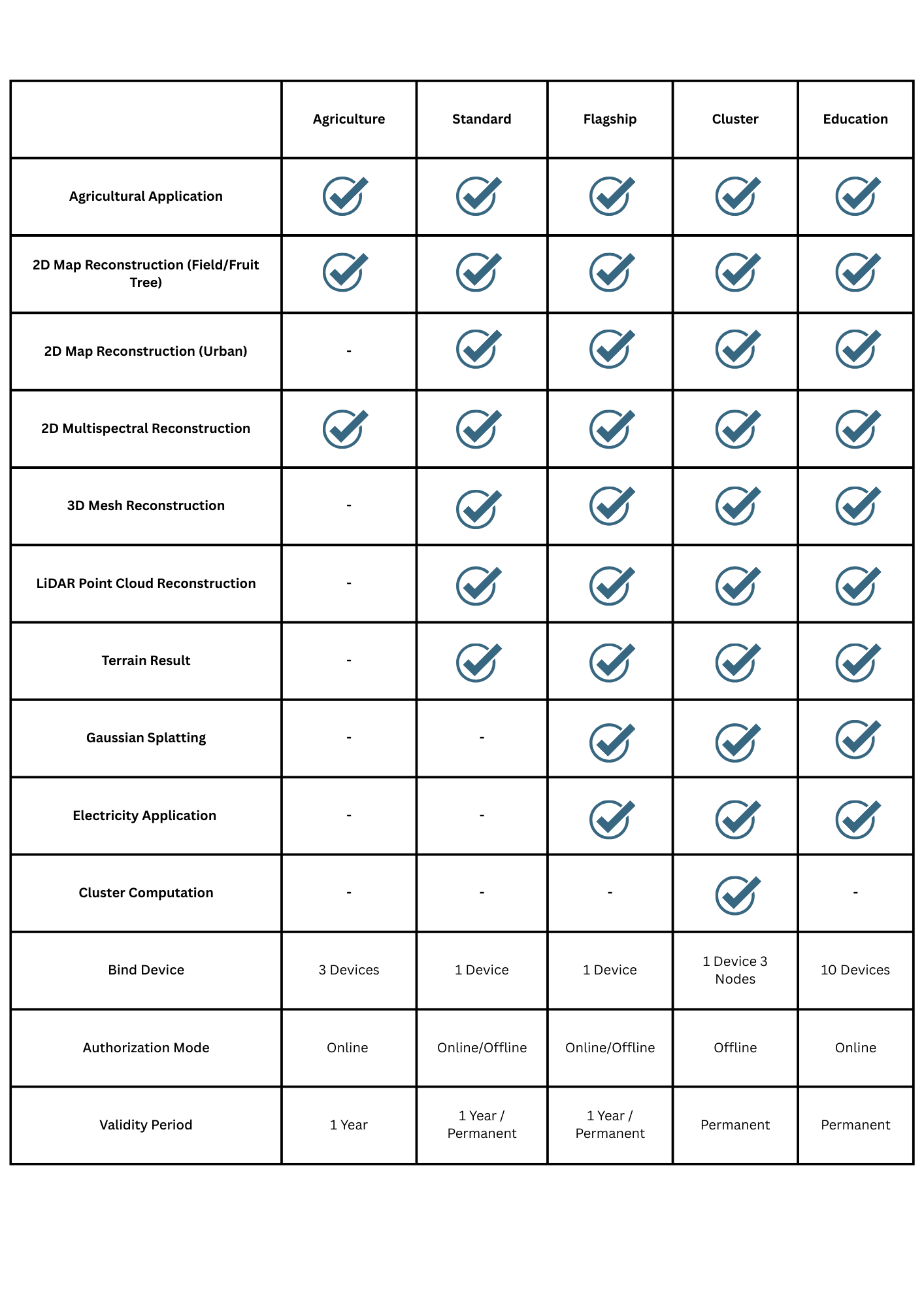
New Licence Options
The new license structure includes five distinct categories: Agriculture, Standard, Flagship, Cluster, and Education. Each license type targets specific industry requirements and usage scenarios, ensuring users access appropriate features without paying for unnecessary capabilities.
DJI Terra represents a transformative advancement in professional drone mapping software, combining revolutionary Gaussian Splatting technology with comprehensive workflow enhancements. These updates deliver unprecedented processing speed, visual quality, and operational flexibility that address the evolving demands of modern surveying and mapping professionals.
For comprehensive support and guidance on implementing DJI Terra in your operations, contact Survey Drones Ireland at (01) 456 8650 or email info@surveydrones.ie. Our expert team is ready to help you harness the full potential of these groundbreaking mapping technologies.