Elevating the DJI Enterprise Drone Experience: Firmware 7.1
DJI, a pioneer in drone technology, is proud to introduce Firmware 7.1, the latest milestone in the ongoing commitment to enhancing the user experience, safety, and capabilities of the Enterprise drone series. This comprehensive update extends its impact across multiple products, from our latest drones to advanced software solutions and even post-purchase support.
Geocaging for Site-Specific Control
Take command of your drone’s location with precision like never before, ensuring site-specific control.
Compatible solutions: FlightHub 2 + DJI Dock and M30 Series
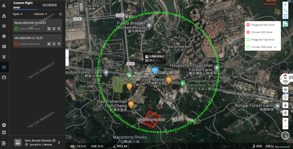
For companies managing drone operations in worksites, the challenge of ensuring both operational safety and efficiency can be significant. The new FlightHub 2 feature, Geocaging, is designed for the DJI Dock and M30 Series aircraft. It allows you to define restricted fly-zones within a FlightHub 2 project. This feature ensures that all docks and M30 Series aircraft associated with the project remain within the designated fly zones as set by the user. You have the flexibility to toggle off different fly zones based on your specific needs.
This feature is especially valuable for companies overseeing critical asset inspections and areas where drones must avoid flying. It also enables companies to establish limits for Beyond Line of Visual Sight (BLVOS) operations, depending on regulatory approvals.

Offline Geofencing Unlocking
Enjoy extended capabilities even in remote areas and share pinpoint coordinates seamlessly.
Compatible Solutions: Matrice 350, Matrice 300, Matrice 30 Series, Mavic 3 Enterprise Series
When operating in remote areas without an internet connection or for data security, users can now download a GeoZone unlocking certificate to the remote controller. This can be accomplished without an internet connection. Users can transfer the key to the remote controller using an SD card and activate it through the DJI Pilot 2 app.
FlightHub 2 Live Flight Controls Update
Compatible Solutions: FlightHub 2 + DJI Dock
Live Flight Controls in DJI FlightHub 2 offers the ability to remotely control both the aircraft and gimbal in near real-time through cloud connectivity. This functionality enhances the flexibility of DJI Dock operations. The latest update includes:
PSDK Control: M30 Series Dock Version aircraft now support various payloads through DJI Payload SDK, such as speakers and spotlights. FlightHub 2 includes new widgets that allow users to remotely control these payloads.
Thermal Palette and SBS Display: Users can switch between different palette options or view both infrared and visual feeds side-by-side.
RNG (Laser Rangefinder) and PinPoint: The M30 Series and H20T come equipped with a laser rangefinder, which is now accessible through FlightHub 2. After enabling the laser rangefinder, users can obtain location/object coordinates and measure distances. The option to create a PinPoint in the center of the camera view is also available, making it useful for marking objects or locations during inspections.

AirSense Display for Safer Operations
Enhance safety with real-time awareness of nearby aircraft, prioritizing safer skies.
Compatible Solutions: FlightHub 2 + DJI Dock
DJI Dock facilitates remote operations; however, in compliance with regulations in various regions, it’s often necessary to maintain visibility of nearby aircraft to ensure safe and controlled operations. DJI AirSense is the solution, employing ADS-B In technology to provide remote operators with real-time visibility of nearby aircraft equipped with ADS-B Out transmitters.
The ADS-B In receiver on the M30 Series Dock Version aircraft activates upon power-up. DJI AirSense calculates the real-time collision risk with surrounding manned aircraft and conveys warning messages through DJI FlightHub 2 based on the assessed risk level.
Offline Geofencing Unlocking
Enjoy extended capabilities even in remote areas and share pinpoint coordinates seamlessly.
Compatible Solutions: DJI Pilot 2, Matrice 350, Matrice 300, Matrice 30 Series, Mavic 3 Enterprise Series
During critical operations, the ability to easily share the location of a subject of interest with ground teams is paramount. DJI Pilot 2 now offers the capability to share a pinpoint location by generating a scannable QR code that can be used to view the coordinates on your phone’s map app.
Once scanned, your mobile app will display the coordinates, allowing you to easily share them with your team members or store them for future reference.
Optimized Interface for Effortless Mission Planning
Simplify your drone missions with the sleek, intuitive interface.
Compatible Solutions: DJI Pilot 2, Matrice 350, Matrice 300, Matrice 30 Series, Mavic 3 Enterprise Series
Planning mapping missions on the DJI Pilot 2 app is now more streamlined with an improved planning interface. The previous Mapping mode and Oblique mode have been merged into the Area Route, simplifying location planning and search functionality. When defining mapping areas, users can select vertices to determine altitude and calculate the required flight height based on the desired Ground Sample Distance (GSD). For M3E/M3T, Real-Time Terrain Follow can be enabled by selecting “AGL” in the “ASL/ALT” section and turning on the Real-Time Follow option.
The Advanced Settings provide additional options, including selecting the start point in mapping missions and adjusting the camera angle.
Safe Return to Home (RTH)
With enhanced RTH, ensure your waypoint missions are not just efficient but safer than ever.
Compatible Solutions: Matrice 30 Series, DJI Dock, FlightHub 2, DJI Pilot 2
When planning waypoint missions, users now have the option to designate waypoints as “No-Return Points.” These waypoints signify areas where traditional RTH may not be possible due to height risk or complex environments. In such instances, the drone will abandon the typical RTH route and instead return home following the waypoint mission path until it reaches the last safe waypoint. It will then calculate the RTH fly path from there.
This feature is particularly beneficial for inspection missions involving critical components and environments where traditional RTH may pose a risk. In cases where missions are interrupted due to factors such as low battery, adverse weather, or signal loss, users can resume missions, taking into account previously designated No-Return Points. The drone will fly to the last available safe waypoint and continue the mission from there, following the waypoints.
Set Gimbal Angle for POI Orbit:
Compatible Solutions: Mavic 3 Enterprise Series
For users employing Point of Interest (POI) Orbit for reconstruction, it is now possible to set the gimbal angle while moving the drone up and down. This enhances control and precision during reconstruction missions.
Flyaway Coverage Now Available:
*Compatible Solutions: Mavic 3 Enterprise Series and Matrice 30 Series
