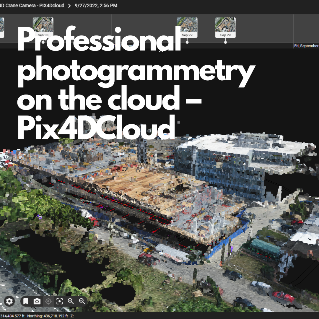
Professional photogrammetry on the cloud – PIX4Dcloud & PIX4DcloudAdvanced
In the rapidly evolving world of drone technology, the ability to quickly transform aerial imagery into actionable data has become a game-changer for professionals across multiple industries. Enter PIX4Dcloud – a cloud-based platform that’s redefining how we approach photogrammetry and aerial data processing.
What is PIX4Dcloud?
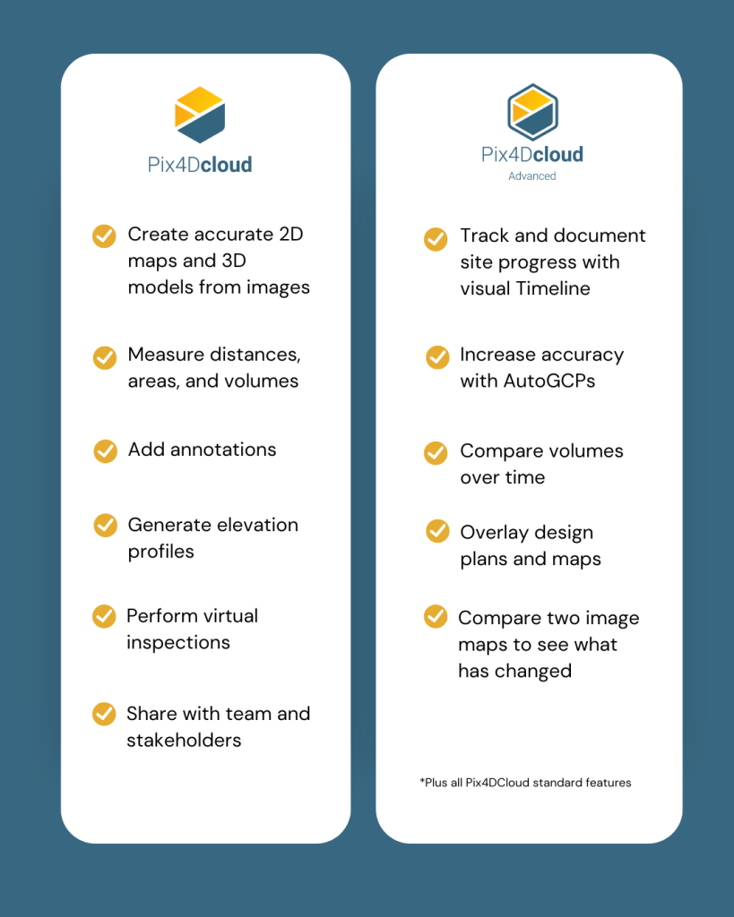
PIX4Dcloud is a comprehensive online platform designed for ground and drone mapping, progress tracking, and site documentation. This advanced cloud-based solution streamlines the entire workflow from image capture to final deliverables, eliminating the need for expensive hardware and complex software installations on local machines.
The platform stands out in today’s technology-driven landscape by offering robust data management systems combined with sophisticated photogrammetry algorithms, all accessible through a user-friendly web interface. There are two versions of the software PIX4Dcloud & PIX4DcloudAdvanced, depending on your needs.
What Makes PIX4Dcloud and PIX4Dcloud Advanced Stand Out in the Industry
Easy to Use Interface
One of the most compelling aspects of PIX4Dcloud is its accessibility. You can start a new project in minutes. The intuitive platform removes the technical barriers that often prevent professionals from leveraging photogrammetry technology.
Straightforward Communication
Collaboration is seamless with PIX4Dcloud. Share your project status with team members and stakeholders with just a click of a button, ensuring everyone stays informed throughout the project lifecycle.
Up-to-Date Documentation
Maintain permanent and up-to-date records of your projects while resolving disputes efficiently. The platform serves as a comprehensive documentation system that grows with your project.

The Four-Step PIX4Dcloud & PIX4DcloudAdvanced Workflow
Capture
Collect site images using various methods:
- Drones (most common approach)
- Handheld cameras
- PIX4Dcatch direct upload from device
Process
The magic happens in the cloud. PIX4Dcloud automatically processes your images using advanced photogrammetry algorithms to transform them into measurable deliverables. The platform generates:
- Accurate and georeferenced orthomosaics
- 3D meshes
- Point clouds
- Elevation models
- Gaussian Splat output
Analyse
Visualise, monitor, and document site progress using an intuitive interface. The built-in timeline and measurement tools are accessible online from any device or location, making it perfect for field work and remote collaboration.
Share
Distribution is effortless – simply share results with your team or clients through a URL, ensuring seamless information flow and enhanced collaboration.
New feature for PIX4Dcloud & PIX4DcloudAdvanced
Gaussian Splatting Feature Now Available in PIX4Dcloud for PIX4Dcatch
PIX4Dcloud now supports Gaussian Splatting for PIX4Dcatch datasets, offering enhanced visualisation of 3D scenes with exceptional photorealistic detail and density. This advanced feature significantly improves the rendering quality of reality capture projects directly in the cloud. It marks a substantial step forward in how mobile LiDAR and image data can be shared, viewed, and interpreted.
https://cloud.pix4d.com/dataset/2178779/model?shareToken=53cfbcb0-3d24-4363-9631-d07d7ff76ceb
What is Gaussian Splatting?
Gaussian Splatting is a cutting-edge technique used to render 3D scenes by projecting millions of tiny, semi-transparent 3D Gaussian “blobs” (or “splats”) instead of traditional polygons or mesh structures. Each splat contains information such as position, colour, size, orientation, and opacity, which makes it ideal for real-time, high-quality visualisation of complex scenes—like those captured using photogrammetry or LiDAR.
Why It Matters for PIX4Dcatch and PIX4Dcloud
- No meshing needed: It skips the time-consuming mesh reconstruction step, rendering detailed 3D outputs much faster.
- Photorealistic output: Splats naturally blend into one another, providing smoother, more realistic visuals, especially for organic or complex surfaces.
- Real-time viewing: Ideal for cloud platforms like PIX4Dcloud, where users want instant, immersive views of their captured environment.
Pricing Plans and Allowances
PIX4Dcloud offers flexible pricing options to accommodate different project scales and requirements:
Trial Option
- PIX4Dcloud trial: This licence is valid for 15 days from the date of activation. It allows access to PIX4Dcloud Demo Projects, you can upgrade to the PIX4DcloudAdvanced trial.
- PIX4Dcloud Advanced trial: This licence is valid for 15 days from the date of activation. It includes 40 processing credits, which are sufficient to process up to 200 images captured using a DJI Mavic 3 Enterprise drone.
Monthly Billing
- PIX4Dcloud: This Licence is valid for 30 days from the date of activation. It includes 20 processing credits, allows unlimited amount of project sharing, allows Measurement & Annotation usage and has access to PIX4Dcatch.
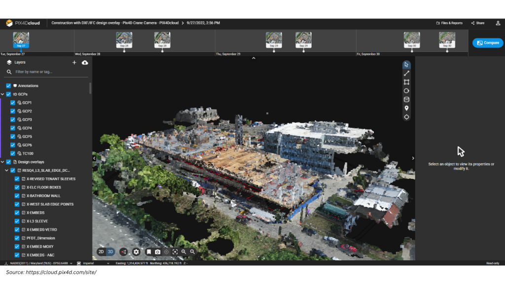
- PIX4DcloudAdvanced: This licence is valid for 30 days from the date of activation. It includes 100 processing credits, allows the same features as PIX4Dcloud, but has extra features which include 2D/3D comparison, PDF reports, DXF & ICF Overlays and timeline view just to name a few extras. (Please see link to full feature list.)
Yearly Billing – Features are the same as the Monthly Licence
- PIX4Dcloud: This Licence is valid for 365 days from the date of activation. It includes 500 processing credits.
- PIX4DcloudAdvanced: This licence is valid for 365 days from the date of activation. It includes 2,500 processing credits.
3 Yearly Billing – Features are the same as the Monthly and Yearly licence
- PIX4Dcloud: This Licence is valid for 3 Years (1,096days) from the date of activation. It includes 1,500 processing credits
- PIX4DcloudAdvanced: This Licence is valid for 3 Years (1,096days) from the date of activation. It includes 7,500 processing credits.
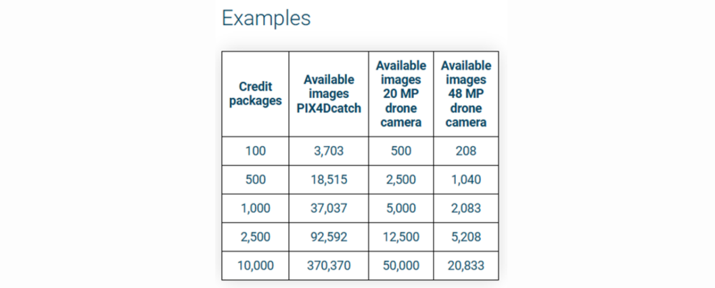
Here is an Example Usage Table for Pix4D Processing Credits
Credits can be purchase at any time through us. If you find you are running low on credits you can get in touch, and we will advise you correctly on the different types of credit packages available. It’s important to note Credits do not expire. You can accumulate credits and use them for processing as long as you have a valid PIX4Dcloud or PIX4DcloudAdvanced license.
PIX4D uses a simple and transparent credit system to estimate how many processing credits you’ll need for a dataset. The number of credits required depends on two main factors: the resolution of your images (in megapixels) and the total number of images. To calculate it, you multiply the image resolution by the number of images, then divide by 100. For example, processing 200 images taken with a 20 MP drone camera would require 40 credits. When creating your project in PIX4Dcloud and PIX4DcloudAdvanced the number of credits required for the project is calculated and displayed.
PIX4Dcloud – Free storage limit
As part of PIX4Dcloud new cloud service offerings, PIX4D has established a Cloud Fair Usage Policy to ensure efficient and equitable resource usage. This policy outlines the storage limits associated with each product license and provides guidelines on actions that will be taken if these limits are exceeded.
PIX4Dmatic, PIX4Dsurvey, PIX4Dfields, and PIX4Dreact: 15 GB.
PIX4Dcloud Basic: 500 GB.
PIX4Dcloud Advanced: 2 TB.
PIX4Dcloud Enterprise or Engine Cloud: 10 TB.
Pix4D strives to provide sufficient storage for its users. However, if it identifies excessive or unfair storage usage, Pix4D reserves the right to occasionally request certain users to reduce their storage usage.
The total storage is not the sum of all licenses. For example, a user with a PIX4Dmatic and a PIX4Dcloud standard license can store up to 500 GB.
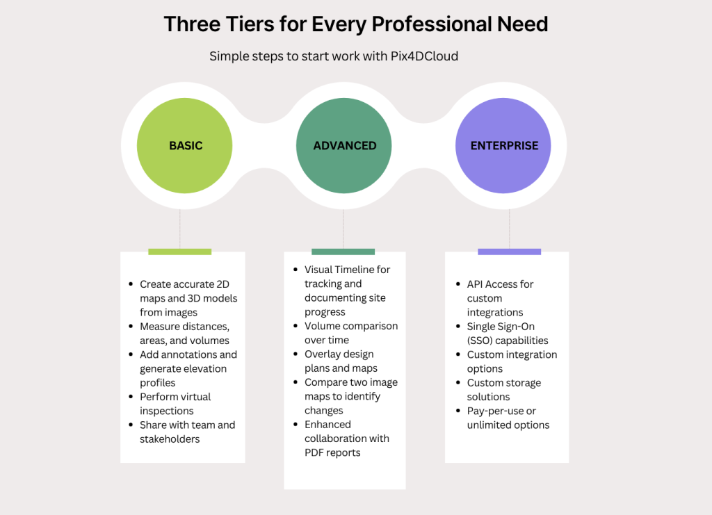
For PIX4DcloudEnterprise please contact us. As this is a tailored Cloud Service for your company. As this licence has further advanced features such as Organisation Management, API Access, Embedded 3D viewer, SSO & Custom integrations.
Industry Applications
PIX4Dcloud & PIX4DcloudAdvanced serves diverse professional sectors:
Surveying & Construction: Monitor project progress, calculate volumes, and maintain accurate site documentation
Agriculture: Analyse crop health, monitor field conditions, and optimise agricultural operations
Oil & Gas: Conduct infrastructure inspections, monitor pipeline integrity, and document facility conditions
Energy & Renewables: Inspect solar farms, wind turbines, and other renewable energy installations
Important Considerations
Data Storage Policy
Projects are maintained on Pix4D servers according to specific storage expiration policies. After license expiration, projects are deleted based on the following timeline:
- Trials: The processed datasets will be deleted 30 days after the expiration unless the user decides to purchase a PIX4Dcloud or PIX4Dcloud Advanced license.
- Monthly/Yearly/3 yearly licenses: The processed datasets will be deleted 6 months after the expiration unless the user decides to renew their PIX4Dcloud or PIX4Dcloud Advanced license
Users receive notification emails 30, 7, and 1 day before deletion for most licenses, and 7 and 1 day before deletion for trials.
Example: A project is created with a PIX4Dcloud Advanced trial. Twenty days after the trial expires, a PIX4Dcloud rental license is purchased. The project will not be deleted.
However, if the rental license is purchased 31 days after the trial has expired, the project will be deleted and no longer accessible.
Ground Control Points
PIX4Dcloud Advanced can accommodate Ground Control Points (GCPs), but they must be of specific types for optimal processing results.
- Squared, diagonal, and Aeropoints targets are supported
- The recommended size is a minimum of 20 times the average GSD of the project
- Black and white targets are supported. Other colors may work in some circumstances.
- GCPs/CPs must be placed at a distance of at least 15 m from each other.
- GCPs/CPs must have a projected coordinate system

The Future of Aerial Data Processing
PIX4Dcloud represents a significant shift toward accessible, cloud-based photogrammetry solutions. By removing hardware constraints and simplifying workflows, it democratises professional aerial data processing for businesses of all sizes.
Whether you’re a surveyor documenting construction progress, an agricultural consultant monitoring crop health, or an energy professional conducting infrastructure inspection, PIX4Dcloud provides the tools needed to transform aerial imagery into valuable business intelligence.
The platform’s combination of user-friendly design, powerful processing capabilities, and flexible pricing makes it an attractive option for professionals seeking to leverage drone technology without the complexity of traditional photogrammetry software.
As the drone industry continues to evolve, cloud-based solutions like PIX4Dcloud are becoming essential tools for professionals who need reliable, accessible, and powerful photogrammetry capabilities. With its comprehensive feature set, flexible pricing, and emphasis on collaboration, PIX4Dcloud is well-positioned to meet the growing demand for professional aerial data processing solutions.
For professionals ready to embrace the future of aerial data processing, PIX4Dcloud offers a compelling combination of sophistication and simplicity that can transform how you approach drone-based projects.
Ready to experience professional photogrammetry on the cloud? Consider starting with a PIX4Dcloud trial to explore how this powerful platform can enhance your aerial data processing workflows.
At Survey Drones we offer Training, Support and Purchasing of all PIX4D software range. Reach out to us as we are Irelands only official PIX4D Partner, our email info@surveydrones.ie