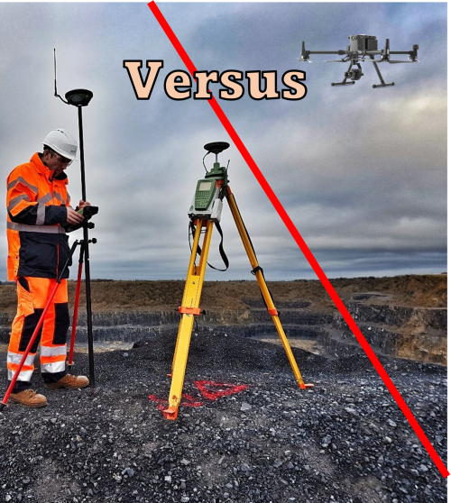
Traditional Surveying and Drone Surveying
Traditional Surveying and Drone Surveying – An Honest Comparison
As drone technology, capability and flexibility develop the sector begins to compete more and more with traditional surveying methods. This is great news for those who wish to survey from the sky however the word ‘compete’ must be used with care.
Drones are very capable data acquisition tools in the right hands however, in many specific applications traditional surveying methods are extremely challenging for drones to match. Operators must be aware of their limitations in delivering quality data and outputs to the client.
Both survey methods have fantastic benefits with some compromises. It is down to you as a knowledgeable surveyor to conclude the best solution considering both the business and data quality.
What is Traditional Surveying?
Within this context we can take ‘traditional’ to mean using either total station, gps or a combination of the two to collect a myriad of topographical information on-site. From this information outputs may include section lines, levels, contours, DTM’s and of course general topographical information. The Leica TS16 total station and GS18T receiver, available from Survey Instrument Services, are both examples of instruments that are used for this method of surveying.
What is Drone Surveying?
Drone surveying can be broken down into two key considerations, the platform and the sensor. The platform can be either multi-rotor or fixed wing with the option of a VTOL system. The sensor can be RGB, multispectral, thermal or lidar with some configurations allowing a combination of two sensors simultaneously. Outputs from drone surveying may include orthophotos, DTM’s, contours, hi-res RGB or thermal inspection imagery and 3D point clouds.
Comparing the Benefits
Benefits of Drone Surveying
- Solid accuracy results although not on par with total stations
- Rapid data acquisition
- Large coverage area
- Orthophoto & 3D point cloud included as a standard product of image based operations (lidar-exclusive sensors will exclude orthophotos)
- Thermal and Multispectral surveys
- Extended visibility
- Contactless data collection potentially increasing safety
Benefits of Over Traditional Surveying
- More reliable and repeatable accuracies
- Independent of weather conditions (excluding extreme conditions)
- Minimal ‘permissions’ required that may delay operations
- Existing skill set for members of staff
- More discrete and less controversial than drones for properties neighboring the site
- Topographical linework already ‘drawn’ before office processing
An Honest Comparison
It is probably fair to say that most discussions on this topic will promote the immense and infinite capabilities of drone surveying. Here we will take some of the key benefits mentioned above and compare them side by side looking at some of the more nuanced day to day challenges between both methods.
Accuracy
Best achievable
In terms of survey methods, nothing will trump the accuracy of a traverse that is performed and adjusted correctly. For projects requiring the highest levels of accuracy drones are realistically a non runner. If the tightest tolerances are not required only then drones be considered. The absolute best results any drone can realistically achieve today are more or less on par with RTK GNSS. This is to say about +/- 25mm however achieving that requires great levels of care with adequate control and data quality. This accuracy can very easily slip well past +/- 50mm on larger scale projects.
Ground Level Problem
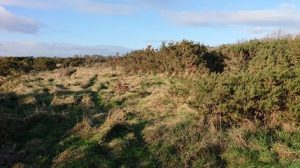
Photogrammetric based surveys will always suffer from one major issue within the discussion of accuracy. That is soft ground. For topographical surveys you will ideally always be able to tell where the ground is to get an accurate level and position. If the ground is obscured by heavy vegetation or often light vegetation it will be almost impossible and certainly not reliable to tell the level of the ground. This may be a small issue as it could be an isolated pocket on-site however, what if the entire survey area is covered in 0.5m tall grass? The image below shows a very real example of how drone data would struggle in such as situation

Immediately with photogrammetry the accuracy has been blown out of the water. Photogrammetry will calculate the ground in the point cloud as the top of this 0.5m grass and will give no indication of the actual ground level.
In this scenario even lidar with it’s increased ground penetrating capabilities will fail to beat a surveyor and pole verify that the correct ground level is being measured. It is down to the surveyor to select which method makes the most accurate and financial sense. Having said this, lidar does have a huge advantage over photogrammetric based surveys in lighter vegetation once good point cloud filtering is applied.
Tailor to the site
It may often be the case that the solution is not binary. Often a client may require high accuracy on hard detail but expect lower accuracy in soft detail. Depending on the job specification, a combination of both traditional and drone will achieve the fastest and most accuracy-adequate results giving the best of both worlds.
Speed and Coverage
This is the greatest commercial advantage drone surveying has over traditional surveying. With a drone solution vast areas of fields, quarries and roads can be surveyed in a day compared to several days of crews using traditional methods.
One major consideration is the site-office balance. With remote sensing methods such as terrestrial laser scanning and aerial surveying it is most often the case that huge quantities of linework will have to be extracted from the point cloud in the office. Compare this to traditional survey methods where the linework is automatically being drawn on-site and will only have to be cleaned before being ready to deliver.
Many of the cost benefits associated with more rapid data collection on site can be mitigated with extensive office based work. This issue is particularly present with topographical surveying. Days saved on site may simply result in days pushed to the office. That is not to say it is the wrong option but most definitely a consideration when assessing the overall speed at which the survey is completed and delivered.
Potential Delays
Drone surveying is far more likely to experience delays compared to traditional surveying. The main culprit is weather followed by aviation authority permissions.
In Ireland the governing body the IAA are very good and efficient at what they do however, lead in time is required when requesting permission. Depending on the airspace the drone will be flying the permission required may take upto a week or more to clear before any take-off can be performed.
The weather in countries such as Ireland is ever changeable and must be monitored regularly before heading on-site. If drones are the main function of the business, weather may impact many operations however if they are secondary, good weather days may be cherry picked.
Traditional survey methods on site are most definitely slower but are not at the mercy of weather and airspace. With this in mind it still may be faster to perform a drone survey over a traditional survey. Knowing the difference will most likely come with some knowledge and experience as most things do.
Discretion & Privacy
Drones are not everyone’s cup of tea. They make a lot of noise and are capable of taking hi-resolution pictures of anything from low to high altitudes. It is not uncommon for the general public to be suspicious of drones as many are not aware that they actually have professional use cases. Many assume a drone means someone is up to no good. It is therefore a consideration to use a drone or not, given how sensitive an area may be.
Surveys conducted near or above government buildings, Garda stations, prisons, mints, and historical sites must all be pre cleared by the given entity. In many cases this clearance is still required for traditional based surveys but extra suspicion will be raised over the use of a drone. It is important to give notice well in advance as many on-site may be concerned about its use.
Some surveys such as controversial projects and property disputes you may very well be within your legal right to fly. However, the question must be asked. Is it the best idea? Traditional surveys share some of the same issues within this context however, extra consideration must be given to drone operations.
Value Added Data
Alongside speed and coverage, value added data is where drones can really shine. This is the idea that a given method of data collection can not only meet the minimum specification of the job but go above and beyond what is expected by the client.
Take for example a topographical survey. Drones can provide the linework and level information required but on top of that provide a very impressive orthophoto, 3D mesh and textured model as well as marketing images and videos. When a client did not expect these extras it can blow them away, not to mention the upsell potential!

Boots or Wings?
Ultimately it comes down to a balance of several factors. Discussed in the article are just some of those out there. It is often the case that to balance accuracy and financial sense, drones may be used in conjunction with traditional methods. This will likely achieve the best results for the client.
Drones are fantastic tools for surveying however, it is essential to remember that they are not a one-size-fits-all solution and operators should strive to present honest and accurate data to the client. This is the duty of care that is expected and required of the survey industry and if compromised on a large scale will undermine some of the great work of surveyors in Ireland.
