DJI Zenmuse L1
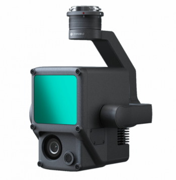
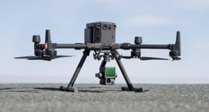
The DJI Zenmuse L1 is DJI’s first lidar sensor to be released. The payload integrates a Livox Lidar unit, 1” RGB sensor and a high accuracy IMU onto a three-axis stabilized gimbal. Much like the Zenmuse P1 for photogrammetry-based surveying, the L1 is exclusively compatible with DJI’s M300 platform.

The L1, L standing for lidar, demonstrates another great example of what is possible with drone-based lidar systems today. It is only in recent years that manufacturers have been able to miniaturise lidar technology to such a point where they can be mounted onto drones such as the M300 with relative ease.
The DJI Zenmuse L1 operates a Livox Avia sensor with a weight of just under 500g resulting in an overall payload weight of 930g. DJI has mentioned that the L1 is the ‘democratisation’ of lidar technology, such is the nature of the more affordable and accessible L1 solution when compared to more traditional aerial lidar sensing.
The L1 is in good company with Livox and its competitors pushing to develop more compact and more accurate lidar sensors for vision systems in autonomous driving cars and robotics. The future for drone-based lidar systems is bright.
Drone-Based Lidar Sensing
The single biggest advantage that lidar has over photogrammetry is its ability to penetrate vegetation to get ground data. Although lidar is not perfect, and the L1 is no exception, it is far more successful than photogrammetry. Where image-based surveys generate noise and messy point clouds in forested areas, the L1 can operate with up to three-point returns to achieve much better results in areas of vegetation. This allows point cloud formats such as .LAS to be cleaned and filtered with confidence.
Point returns are an essential part of lidar systems. Once the beam of energy, light, has left the sensor it can return to the sensor at different levels of strength and at different times. It is most often the case that the first return is achieved by hard detail such as rooftops, roads and paths. However, in areas of vegetation, multiple returns quickly become important for any real ground penetration to be successful.
In operations using single-point returns, the L1 is capable of 240,000 pts/sec which increases to 480,000 pts/sec with double and triple-point returns. To give context to that point rate, Leica’s RTC 360 terrestrial-based lidar produces a rate of up to 2,000,000 pts/sec.
Point Cloud LiveView
The Point Cloud LiveView feature allows users to view scan data in real-time on-site. DJI says that this feature can allow critical decisions to be made immediately which is true however, there is a much more practical benefit to this feature. That is, data verification on-site.
Those familiar with Leica’s latest laser scanners such as BLK and RTC ranges will know that on-site point cloud viewing is a great deal of help in verifying that scan data is matching well and seeing that any missing data is infilled before leaving site. This seems to be the same road DJI has taken but not only that it seems to be the direction the technology as a whole is heading. Real-time viewing and data verification on-site.
With sites often being many kilometers from the office, revisits can be very expensive in terms of money and time. Point cloud LiveView would likely remove this concern when used properly.
Accuracy & Applications
The L1 has a stated system accuracy of 10cm horizontal and 5cm vertical at 50m with a recommended flying height of 50m to 100m. The lidar sensor has a ranging accuracy of 3cm at 100m and can achieve between 100-300 pts/m2. With such accuracies now available for drone-based lidar surveys several applications have opened up for operators.
Three applications in which the Zenmuse L1 and M300 solution will be used most are infrastructure modeling, topographical mapping and forestry.
Using photogrammetry, mapping thin power lines, mesh fencing, pylons, bridge beams, and so on is very challenging. Although not impossible with photogrammetry, lidar removes much of the noise and ‘mush’ seen in photogrammetry-derived point clouds and triangulated meshes.
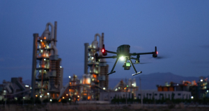
One significant advantage lidar has with detailed environmental objects is its ability to acquire data in shaded areas. Dark shadows are a huge weakness of photogrammetry since the technology is entirely dependent on environmental light. If there is no light in a corner or next to a building due to a bright, low sun then there is simply no data there to acquire and reconstruct. Changing camera settings can compensate but not mitigate the issue. For the reconstruction of detailed elements, lidar is ideal. Moreover, lidar is entirely light-independent meaning night operations are possible.

Much of these advantages are carried over into topographical and forestry applications however, vegetation penetration is even more so an advantage to be seen. With multi-return capability, the L1 can achieve good DSM and DTM datasets even in a reasonably heavy area of vegetation. It must be noted that like any other lidar platform care must be taken to correctly filter and clean the point cloud to determine what exactly is the ground.
RGB Camera
The 1” CMOS sensor with 20MP and the mechanical shutter is right on par with the Phantom 4 series and allows for great point cloud colourisation and photogrammetric results.
DJI’s integration of a Phantom 4-grade camera is a crucial inclusion in the success of the L1 payload. Having the use of an RGB sensor compared to just a lidar sensor opens up more possibilities for end-users. Two significant advantages are colourised point clouds and standalone photogrammetry. Both give those extracting linework from the data an extra helping hand in visualising the point cloud as the environment would be in reality.
Democratisation of Lidar
The DJI Zenmuse L1 is DJI’s first entrance into the world of lidar. Working in conjunction with Livox the company has mentioned that the L1 is the beginning of the democratisation of lidar, enabling a wider range of users access to the technology. It seems that the Zenmuse L1 is the first of exciting things to come for DJI in drone-based lidar sensing.
For more information on the Zenmuse L1, contact one of our experts at Survey Drones Ireland who will be more than willing to assist you in finding what suits your needs.
If you need further advice on this product please send an email to info@surveydrones.ie or fill in the contact page on this website or Click Here to know more.
