PIX4Dmatic
Bigger datasets, accurate results
Fully automated processing
Terrestrial workflow

Fast processing
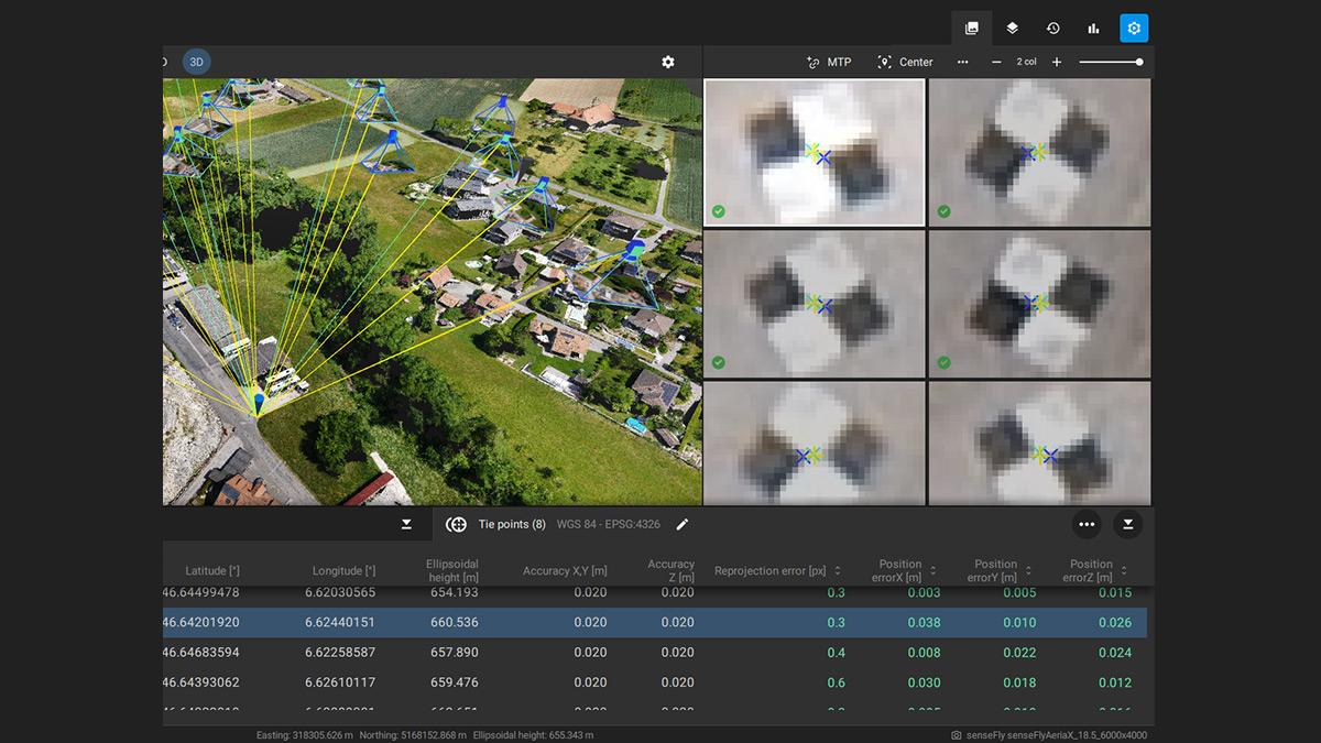
Easy accuracy checks
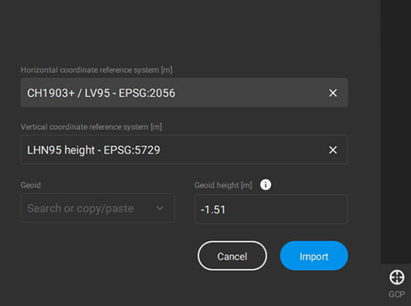
Vertical coordinate systems and geoid support

Import from PIX4Dcatch

Fast development cycles
FAQ.
PIX4Dmatic is a Pix4D product optimised for accurate and fast photogrammetric processing for large scale, corridor and terrestrial projects. It is designed to handle and process thousands of images with ease while maintaining survey-grade accuracy.
PIX4Dmatic is optimized for corridors and large datasets of more than 5000 images with standard camera resolutions such as 12MP, 21MP, 42MP and has no limit on the size of images. Furthermore, PIX4Dmatic fully supports the terrestrial PIX4Dcatch workflow with LiDAR and RGB images processing, as well as a fusion of both results. Finally, learning the software is easier due to the well thought user experience. PIX4Dmatic is faster and more reliable than PIX4Dmapper for such projects:

The calibration step and densification steps are faster in PIX4Dmatic compared to PIX4Dmapper.
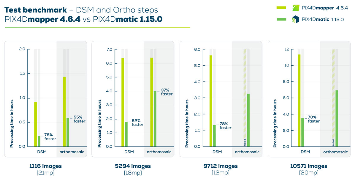
The DSM generation is significantly faster in PIX4Dmatic (up to 82% faster) and the orthomosaic generation is successful even for large projects.
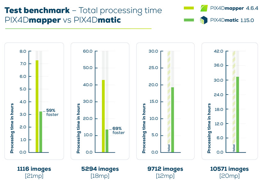
A dataset with 5294 images processed almost 70% faster in PIX4Dmatic compared to PIX4Dmapper.
Point to Note: All projects were processed using the same computer (Windows 10, 8-Core Intel(R) Core(TM) i7-7700K CPU @ 4.20GHz, 64 GB RAM, SSD).
Pix4D subscriptions are renewed month-to-month or annually. They can be canceled any time before the renewal date in your account settings.
This license is not specific to one device. It can be used by one person at a time, but can be logged in to on different devices but not used simultaneously.
No. PIX4Dmatic is a stand-alone product and needs a valid PIX4Dmatic license. A free trial is available for everyone who wants to try. For more information about how to get a trial, please send us an email requesting a trail Licence.
PIX4Dmatic runs on Windows 10 and macOS.
No, to use PIX4Dmatic an internet connection is required.
PIX4Dmatic is a desktop-only application that runs locally on Windows or macOS. The results can be uploaded to PIX4Dcloud in order to be easily shared. (You will need a PIX4D Cloud Licence to achieve this.)
The main PIX4Dmatic inputs are images and ground control points (GCPs). Once processed, it is possible to export dense point clouds, 3D Textured Mesh, DSM, and orthomosaic. It is also possible to import processed PIX4Dmatic projects into PIX4Dsurvey to:
- Vectorize the project.
- Use the Terrain filter, Grid of points and TIN (see DTM workflow in PIX4Dsurvey).
- Calculate volumes.
The full list of input files is available here: PIX4Dmatic’s main inputs
The full list of output files is available here: PIX4Dmatic’s main Outputs
The highest number of images that can be processed with PIX4Dmatic will depend on the processing hardware. Theoretically, the algorithms will scale to any number of images. In practice, we were able to run datasets of 10’000+ images on the PIX4Dmatic Recommended Hardware without issues, which shows there is more potential.
Enquire about a trial of PIX4Dmatic.
Yes, RTK/PPK workflow is fully supported in PIX4Dmatic. Accurate image geolocation and orientation values can be written directly in the EXIF of images or imported in a separate .csv or .txt file.
It is not possible to generate a Digital Terrain Model (DTM) and compute volumes directly in PIX4Dmatic.
However, you can simply open any PIX4Dmatic project in PIX4Dsurvey and use the generated point cloud for further analysis and feature extraction. PIX4Dsurvey can be used to generate a DTM and calculate volumes.
Yes, terrestrial and oblique imagery are supported in PIX4Dmatic. Furthermore, there is a dedicated workflow for terrestrial acquisition with an application for 3D scanning named PIX4Dcatch running on both iOS and Android. Both RGB images and LiDAR of mobile and tablet devices can be used for an optimal modelling experience.
PIX4Dmatic supports input images in WGS 84 geographic coordinate system. If no GCPs are used, the results will be in the corresponding UTM zone.
When using GCPs, a wide range of horizontal and vertical coordinate systems can be selected in the GCP module by either using their names or the EPSG codes.
PIX4Dmatic also includes support for horizontal grid corrections and several geoid models.
Yes, PIX4Dmatic supports global geoids (EGM84, EGM96, and EGM2008) and local geoids, for example, GEOID12B in the US and OSGM15 in the UK.
For local geoids that are not included in the PIX4Dmatic database, it is possible to specify the Geoid height value to convert between ellipsoidal and orthometric heights.
To see the list of supported geoid models check the How to use vertical coordinate systems and geoids in PIX4Dmatic article.


