Skip to content
  • About
  • Drone Blog
  • FAQ
  • News
  • Weather
  • Student Area
giftslogin
0
 
Survey Drones Logo
giftslogin
0
 
    • HOME
    • LICENCING
    • CONSULTANCY
    • TRAINING
    • HIRE
    • Sales
    • SOFTWARE
    • CONTACT

Training Courses

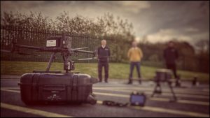
Flight Training Course.

COURSE DESCRIPTION

The Flight Training Course can be tailored to fit your needs. If its your first time flying a drone or you have many, many hours Flying Drones. We can design the Flight Training to your level of training.

COURSE OVERVIEW

The Flight Training Course can be tailored to fit your needs. If its your first time flying a drone or you have many, many hours Flying Drones. We can design the Flight Training to your level of training. We can cover Basic Flight Modes to Advance Modes to Training that will allow you to conduct Inspections of different Structures. We have a wealth of experience in different types of Drone flying from Coast defense, Topographical, Stock Piles, Cinematography and Inspections. Our Instructor has been flying in the Drone commercial Industry for over Six years.

COURSE CONTENTS

Subjects Covered

Introduction to Aircraft

Maintenance of Aircraft

Introduction to FM App

App Settings and Functions

Basic Flight Modes

Flying Basic Flight modes

Camera Settings – Introduction to Shutter Speeds, Apertures (f-stop) Settings, ISO settings, White Balanced explained and others

PREREQUISITES

There is no need to have any prior experience in Flying Drones. This course is designed to give you an understanding of Basic Flight modes and how Drone Data can be captured


Drone Mapping Course.

COURSE DESCRIPTION

This course is designed for Surveyors or Survey companies that are looking to conduct Drone Surveys. They have their Drone Licence. The course covers the workflow that is required for Non-RTK Drones and also RTK Drones.

COURSE OVERVIEW

This course is designed for Surveyors looking to add Drone technology to their list of workflows to capture X,Y,Z data and produce survey grade accuracy deliverable data to their clients. Drone Technology has moved on in the past three years, this course will teach you a workflow that has been tried and tested. The workflow that you learn on this course can be used for any type of Drone weather it be an RTK Drone or a Non-RTK Drone. The workflow was established using a Non-RTK Drone and then modified when RTK Multi-Rotor Drone technology came about.

COURSE CONTENTS

Subjects Covered

Introduction to Ground Control Points.

Introduction to Ground Sampling Distance.

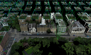
Understanding 2D & 3D Mapping.

Drone App – Mission Planning.

Mission Parameters for 2D & 3D mapping.

PREREQUISITES

There is no need to have any prior experience in Photogrammetry, or Drone Operations. This course is designed to give you an understanding of Photogrammetry and how Drone Data can be unitized and converted into a Point Cloud. On a Non-RTK System and an RTK System.

Pix4D Photogrammetry Course.

COURSE DESCRIPTION

This course is classroom based, The first part is how to input your data and correctly set it up for processing and setting up your output into ITM Co-Ordinates for use in other software like Civil 3d or Autocad. 

COURSE OVERVIEW

This is a Step By Step type of Training so a Lot of Notes would be taken and the process explained in detail. We cover all the functions for the processing steps and explain each function. The Data we normally use is your data that you have captured during the “Drone Mapping with GCP’s Course”. If you have not taken this course we will provide you with our data sets. This Course is a One day Course.

COURSE CONTENTS

Subjects Covered

Introduction to Features and Functions

Drone Data Capture

Step 1 Process Explained and demonstrated

WGS84 TO ITM Conversion explained with regard to Heights on the z axis.

Step 2 Process Explained and Demonstrated

Point Cloud Editing

Step 3 Explained and Demonstrated

Orthomosaic Editing

PREREQUISITES

There is no need to have any prior experience in Photogrammetry. This course is designed to give you an understanding of Photogrammetry and how Drone Data can be unitized and converted into a Point Cloud.


Training Courses

Showing all 4 results

  • EU Open Category A2

    EU Open Category A2

    €149.00
    Add to cart
  • EU Specific Category Theoretical Ground School Course

    €750.00
    Add to cart
  • Flight Training Survey Drones

    Flight Training

    €800.00
    Add to cart
  • Pix4D Software Training

    Pix4D Software Training

    €800.00
    Add to cart
“

I Completed the Ground School Training and exam with Survey Drones Ireland and then completed the Flight Test. I found the instructor very helpful during the duration of the course and he covered everything and after the course and exams he was still very helpful and I would highly recommend Survey Drones Ireland.

www.dronephotography.ie

Richard Coleman, Drone Ground School Course.

Two of our operators completed the Ground School Training and exam with Survey Drones Ireland. We then followed up by completed the Flight Test and some Pix4D training. I found Wayne very knowledgeable on all aspects and could get the information across in a straight forward easy to learn manner. I would highly recommend Survey Drones Ireland for any training needs, and we will be using them again in the future.

www.glenturas.com

Paul Gallagher, Drone Ground School Course.

I would like to to take this opportunity to thank Survey Drones Ireland for providing the drone flight school course online, for me it was a renewal. The fact the course this time, was online and not in a classroom environment for me it was a bonus, I could attend in the comfort of my own home, no stressing with Dublin traffic and nobody had to worry about social distancing. The course was delivered with great professionalism with many practical examples and advice. It certainly didn’t feel as if he was sitting in a room on his own talking to a screen, he encouraged plenty of interaction making people feel part of the course not just a student watching an online course.

Wayne is a wealth knowledge of the industry, he has a passion for everyone to succeed and be SAFE. What he’s learned in his years, he’s more than willing to share. He also encourages people to contact him after the course if the need any advice. I would certainly recommend Survey Drones course to anyone, professionals and hobbiest alike.

www.mcdonaldsurveys.ie

Aidan Stewart, Drone Renewal Course

“I completed the Ground School Training with Survey Drones Ireland in the middle of a COVID-19 lockdown, through an online classroom setting. While I thought the online setting might be a bit ‘cold’ it actually wasn’t, it worked very well and there was good interaction encouraged, plus I had the added bonus of a very short commute to my home office. It was great to get Wayne’s insights into the multi-faceted aspects of drone flying, and his wealth of experience was obvious. The follow up afterwards has also been terrific. Highly recommend. I think it works much better when everyone keeps their cameras on while the training is ongoing.” – Aidan Fidgeon, Dublin Airport

Aidan Fidgeon, Drone Ground School

OUR CLIENTS

CONTACT Dublin: (01) 456 8650
Cork: (021) 423 2957
info@surveydrones.ie
Monday – Friday 9.00am – 5.30pm
LINKS
  • Cookies Policy
  • Private Statement
  • Contact
  • Terms & Conditions
  • Gift Voucher
Logo

fb tw ins linked
© 2022 Survey Drones Ireland. All rights reserved.
Website Developed by Flo Web Design